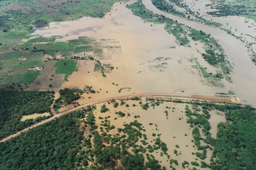
In northern Ghana, floods along the White Volta River are more than seasonal disruptions. They destroy crops, threaten food security and displace communities. Each year, heavy rainfall combined with upstream water released from the Bagre Dam in Burkina Faso destroys agricultural fields of vulnerable communities in flood-prone districts near the White Volta Basin in Ghana.
The International Water Management Institute (IWMI), as part of the Pan-African and Transdisciplinary Lens in the Margins: Tackling the Risks of Extreme Events (PALM-TREEs) project, partnered with local researchers from the Kwame Nkrumah University of Science and Technology (KNUST) in Ghana, to develop a flood risk assessment tool. In line with PALM TREEs’ commitment to strengthening local capacity, IWMI supported an early-career researcher in generating flood risk maps. Together, IWMI and KNUST early-career researchers built actionable flood risk maps that can guide land-use planning at the district level, enhancing community resilience to flood impacts.
Flood risk maps are more than just data points — they are tools that help people protect their lives and livelihoods. For farmers, these maps highlight high-risk zones, guiding them to make smarter decisions on where to plant crops or when to relocate, so their hard work is not washed away by rising waters. For communities, they serve as a backbone for early warning systems, helping leaders plan safe evacuation routes before disaster strikes. They build awareness, empowering people with practical ways to reduce risks and stay safe when floods come.
Accessible flood risk maps enable smarter flood management
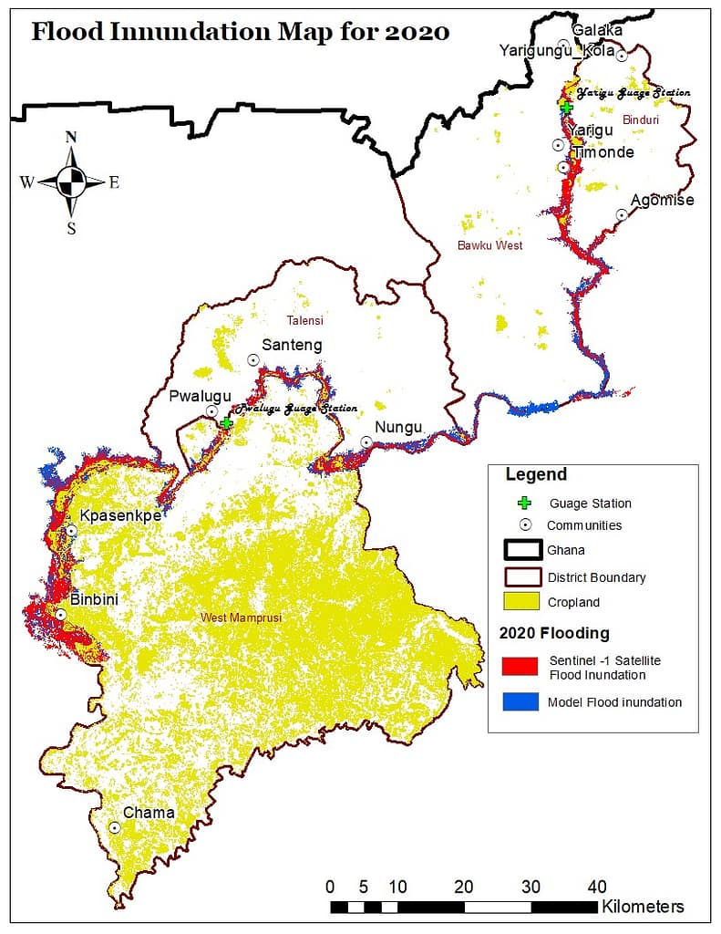
The researchers used flood risk mapping to assess the vulnerability of communities in four flood-prone districts in northern Ghana. For families in Binduri, Bawku West, Talensi and West Mamprusi increasingly unpredictable flooding has jeopardized their agricultural livelihoods. To calculate future risks, researchers simulated a flood event in September 2020 and validated it with Sentinel-1 radar satellite imagery. The satellite imagery was used to assess flood exposure risk by overlaying inundated areas against agricultural land and settlements, enabling a quantified understanding of impacts on local communities.
Results showed high consistency between model and satellite observations in flood mapping across the Binduri, Talensi and West Mamprusi districts. The district-level exposure analysis revealed significant risks to agriculture with up to 18% of farmland impacted by flooding. Communities such as Binbini, Nungu, Timonde, Kpasenkpe and Yarigu emerged as particularly vulnerable, with both agricultural land and households regularly inundated. Insights translated through visualized flood maps and district-level quantified exposure graphics provide compelling evidence for local authorities and stakeholders to prioritize critical interventions for the most at-risk communities.
These maps demonstrate the power of combining numerical flood modeling with Earth observation data to provide robust, evidence-based insights that support climate-smart land-use planning and disaster risk reduction.
The research findings underline the urgent need for informed land-use planning that avoids settlement and cultivation in high-risk flood zones. It provides insights into integrating seasonal forecasts and early warnings to reduce crop losses and to embed flood risk maps into district-level disaster management and climate adaptation strategies.
Stronger community resilience requires sustained capacity building
To strengthen resilience, IWMI and partners have prioritized to build the capacity of some of Ghana’s most flood-affected communities at multiple levels. This includes equipping marginalized communities with knowledge, building the technical capacity of local researchers and generating district-specific flood risk maps. This empowers these communities to better respond to extreme climatic events such as droughts, floods and heat waves, including the interconnected and cascading socio-economic impacts of these disasters.
Looking ahead, the project hopes to build on this momentum, further equipping communities with capacity-building measures to strengthen their disaster resilience. These include promoting flood-resilient crops and farming techniques, implementing index-based flood insurance systems, and building local capacity for emergency response and recovery through existing village savings and loans associations.
As floods become more frequent, translating flood risk data into concrete action is essential for protecting lives, livelihoods and food security in Ghana.
*Co-author Samuel Owusu Ansah is a PhD candidate at KUNST, Ghana. As an early career researcher supported by the PALM TREE project Samuel led the development of flood risk maps for the White Volta Basin.


