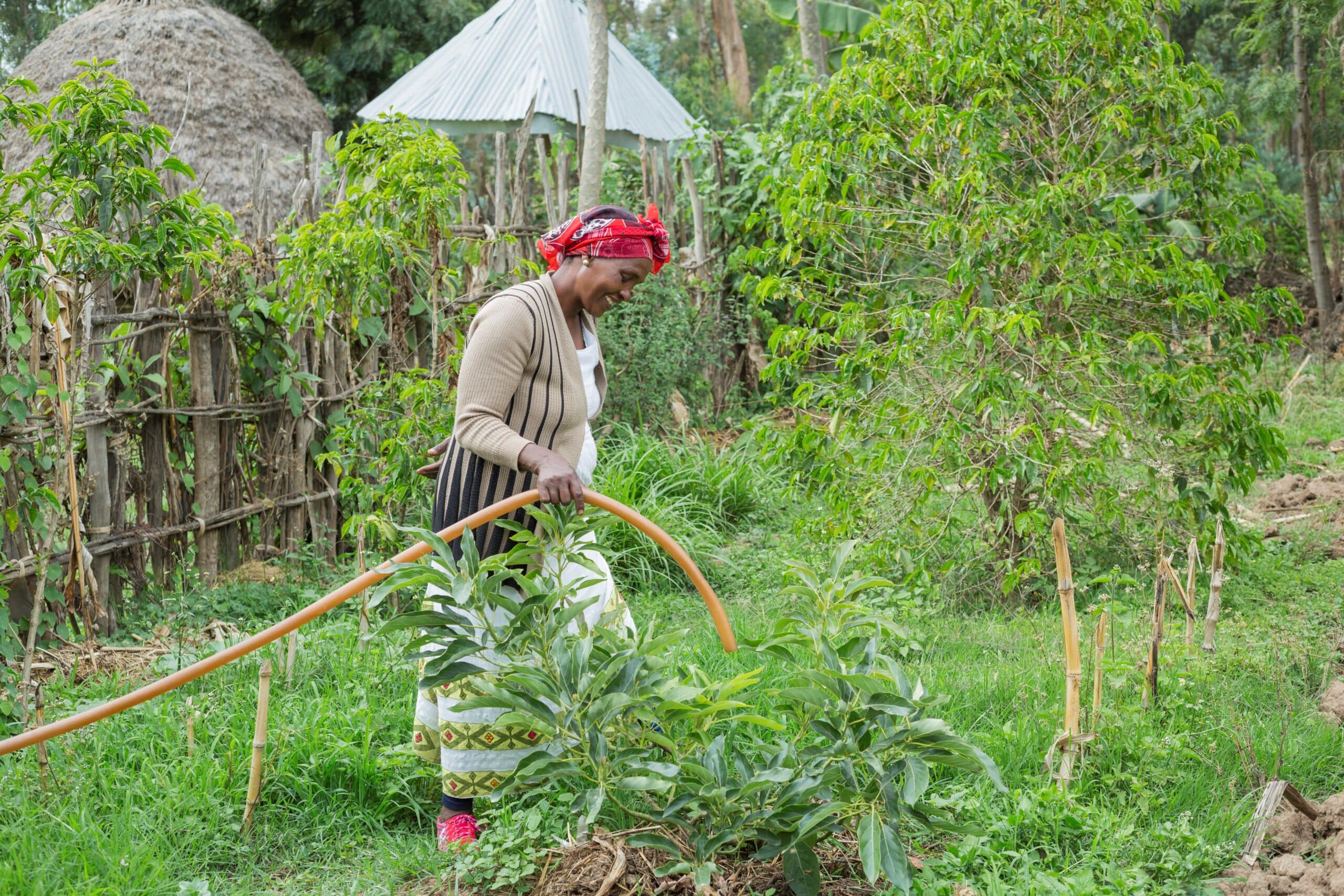
Ethiopia, located in the Horn of Africa, has a diverse climate ranging from temperate highlands to arid lowlands, with significant rainfall variability across regions. Agriculture is the backbone of Ethiopia’s economy, employing the majority of the population. The country’s dependence on rain-fed agriculture makes it particularly vulnerable to shifts in rainfall patterns and droughts, which exacerbate food insecurity and livelihood challenges.
IWMI in Ethiopia
Based in Addis Ababa, Ethiopia, IWMI researchers are focused on enhancing agricultural resilience and promoting sustainable natural resource management through innovative approaches to land, water, and irrigation. A key focal area is improving irrigation infrastructure and water management systems, with projects such as the development of an Irrigation Infrastructure Quality Management System toolkit. This toolkit, applicable across Sub-Saharan Africa, is helping to enhance the quality and effectiveness of irrigation systems in Ethiopia, as well as in neighboring Kenya and Uganda.
Additionally, IWMI is implementing climate-smart agricultural practices to improve livelihoods and build resilience among smallholder farmers, particularly through improved water and nutrient management. Our work in landscape rehabilitation, such as in Halaba, emphasizes the restoration of degraded land, supporting ecosystem services and sustainable agricultural practices. IWMI is also addressing water management challenges in regions like the Awash River Basin, working with communities to prioritize climate-smart water management practices that enhance both water availability and productivity. In the Bale Ecoregion, researchers are examining the impact of land use and land cover changes on ecosystem services, which informs strategies for maintaining the health and productivity of these landscapes. These initiatives, alongside efforts to promote financial inclusion and sustainable resource management, are collectively contributing to Ethiopia’s path toward a more resilient, sustainable, and climate-smart agricultural future.
Climate change remains a significant threat to farm households, especially in developing countries. It exacerbates their vulnerability to food insecurity by reducing agricultural productivity and raising agricultural production costs. Adoption of climate smart-agricultural (CSA) practices is a promising alternative to build resilient farm households. In this study, we assessed the impacts of adopting CSA practices on climate resilience and vulnerability among farm households in Bale-Eco Region, Ethiopia. A power calculation was used to determine the sample size, and 404 farm households were randomly selected to collect data using structured questionnaire. We estimated household climate resilience index using categorical principal component analysis, and vulnerability index using vulnerability as expected poverty approach. Endogenous switching regression model, which is conditional on the adoption of multiple CSA practices and used to control selection bias and unobserved heterogeneity, was used to assess the impacts of CSA practices on household climate resilience and vulnerability. We employed counterfactual approaches to assess the impacts. The results show that the average treatment effects for most CSA practices are statistically significant and positive for resilience, but negative for vulnerability. This provides empirical support for interventions in climate-smart agriculture, which can help farm households build resilience and reduce vulnerability. We, therefore, suggest that agricultural policies should encourage the adoption of CSA practices and provide incentive packages to farm households that promote this.
There is an urgent need to expand wastewater treatment on the African continent. To help choose appropriate technologies for this task, we evaluated the efficiency, energy and chemical demands, and costs of four wastewater treatment plants (WWTPs). These plants represent the main wastewater treatment technologies operated by the Addis Ababa Water and Sewerage Authority (AAWSA): waste stabilization pond (WSP), anaerobic baffled reactor (ABR), up-flow anaerobic sludge blanket with trickling filter (UASB-TF), and membrane bioreactor (MBR) technologies. Principal component analysis revealed that season significantly impacts the raw and treated wastewater quality (ANOSIM, R ¼ 0.3126, p ¼ 0.001), while the type of treatment plant did not significantly affect the measured effluent characteristics (ANOSIM, R ¼ 0.1235, p ¼ 0.2000). In contrast, construction and operational costs, as well as energy and chemical demands per m3 of treated wastewater, varied starkly between the WWTPs. Total costs of wastewater treatment in 2022 ranged from $0.045 to 0.546 per m3 of wastewater treated, being 6–12 times higher for MBR compared with the other WWTP technologies. Real-world performance data as reported in this study are essential for choosing appropriate technologies that meet Africa’s wastewater treatment needs.
Infrastructure / Costs / Water quality / Sustainability / Sanitation / Technology / Energy demand / Economic analysis / Performance assessment / Wastewater treatment plants Record No:H053621
Historically, Ethiopia has experienced recurrent droughts and floods, which may intensify due to climate change. This study has evaluated the performance of 45 models from the Coupled Model Intercomparison Project Phase 6 (CMIP6) in simulating ten extreme precipitation indices against corresponding indices from the Enhancing National Climate Services (ENACTS) during short rainy (February–May, FMAM) and main rainy (June–September, JJAS) seasons for the period 1981–2014 over Ethiopia. Ensemble mean of the top-ranking models are also evaluated against ENACTS in reproducing extreme indices over five Agro-ecological zones (AEZs) of the country. The Taylor Skill Score (TSS) was used to rank the performance of the individual CMIP6 models for JJAS and FMAM seasons with respect to ENACTS while Comprehensive Rating Metrics (RM) were used to compute the overall ranks of the models. Our results show that most CMIP6 models reasonably captured the spatial distribution of the seasonal extreme precipitation indices even though they could not reproduce the magnitude of indices, especially in the highland and high rainfall areas of the country such as Northwest and west parts of the country. However, the biases in lowland and low rainfall regions, such as the eastern and northeastern parts of the country, are smaller compared to other areas. More than 30 CMIP6 models underestimated the extreme indices with the exception of consecutive wet days which is grossly overestimated in the highland and high rainfall areas specifically in western parts of the country. Additionally, EnseMean in the tropical and desert AEZs performs particularly better in simulating extreme indices compared to other AEZs. The ensemble mean of the top-ranking models (EnseMean) generally outperformed both individual models and ensemble of all models in the representation of observed extreme indices across all metrics and seasons. Moreover, the performance of individual models is subject to variation based on the season, and the selected extreme indices. It is also noteworthy that their performance is relatively less influenced by horizontal resolution. Further evaluation, focusing on teleconnections such as ENSO and IOD, is a crucial next step for evaluating models and creating a sub-ensemble.
Datasets / Spatial distribution / Agroecological zones / Extreme weather events / Precipitation / Evaluation / Climate models Record No:H053607
Groundwater is one of the most vital natural resources worldwide. However, shallow aquifers are prone to contamination, posing significant risks to human health, livestock, agricultural productivity, and economic growth. Identifying appropriate land management strategies is critical for mitigating groundwater vulnerability to pollution. This study evaluates groundwater vulnerability to pollution under various land management scenarios using the modified DRASTIC model in Bahir Dar City, Ethiopia. The analysis incorporates multiple parameters within the ArcGIS environment, including depth to water table, net recharge, aquifer characteristics, soil properties, topography, vadose zone, hydraulic conductivity, and land use/land cover (LULC). In this study, LULC was added as an additional parameter to enhance the DRASTIC model. Groundwater vulnerability to pollution was evaluated under four distinct land management scenarios: baseline, agricultural expansion, urbanization, and reforestation. A single-parameter sensitivity analysis and a map removal sensitivity analysis were performed to identify the most influential parameters affecting groundwater vulnerability under the baseline LULC conditions. The result revealed that groundwater vulnerability in Bahir Dar City under baseline conditions is primarily influenced by LULC and net recharge. The areal average groundwater vulnerability to pollution index at the baseline scenario was 184. Agricultural expansion and urbanization increased the areal average groundwater vulnerability to pollution by 4.9 % and 1.6 %, respectively, while the reforestation scenario reduced it by 1.6 %. These findings highlight the critical role of effective land management practices, such as reforestation, in mitigating groundwater susceptibility to pollution. The results also indicate that groundwater vulnerability to pollution varies across different geological formations. Therefore, given the influence of geological variability on groundwater vulnerability, incorporating geological considerations into urban expansion planning is essential for minimizing the risk of groundwater contamination.
Models / Groundwater table / Aquifers / Land cover / Land use / Spatial analysis / Land management / Vulnerability / Groundwater pollution Record No:H053606