Located in Ethiopia’s Awash River Basin, the Amibara Irrigation Scheme is critical in supporting agricultural production across the country’s semi-arid lowlands. Over the past decades, however, its performance and sustainability have continuously declined due to a range of interconnected challenges, including aging infrastructure, poor water management, salinity buildup, canal siltation, the spread of invasive acacia species such as prosopois juliflora, and the growing frequency of climate-induced shocks such as flooding. These challenges have reduced water supply from the irrigation system and intensified competition for limited water resources.
Recognizing the urgent need to rehabilitate and modernize the irrigation system, and in response to a request from the Ministry of Irrigation and Lowlands, the International Water Management Institute (IWMI), through the Digital Innovation for Water Secure Africa (DIWASA) project, conducted a comprehensive water accounting assessment of the Amibara Irrigation Scheme in collaboration with the ministry. Between August 2024 and June 2025, this exercise assessed the scheme’s current performance and identified inefficiencies and evidence-based interventions for its revitalization.
Digital mapping of the scheme
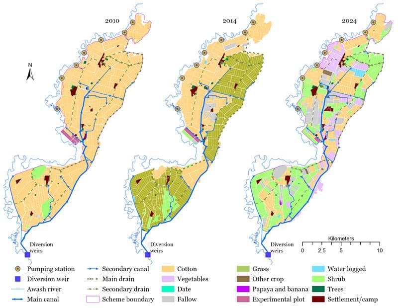
As a first step, IWMI researchers digitally reconstructed the scheme layout map that captures all canals, structures, and irrigated command areas.
During the process, the researchers also developed crop type maps for the years 2010, 2014 and 2024 to track shifts in land use. These maps showed that in 2010 cotton was the dominant crop; the map for 2014 highlighted a policy-driven shift to sugarcane; and the map for 2024 captured a significant land use change due to floods that occurred in 2020 and the spread of prosopis juliflora, thereby reducing effective cultivated areas.
Analyzing irrigation performance
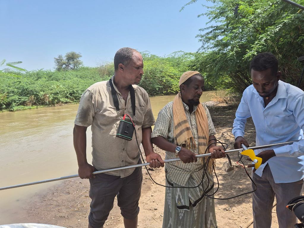
The assessment applied the Water Accounting+ (WA+) framework to analyze irrigation performance. Irrigation water supply was monitored through field measurements between December 2024 and March 2025 to validate the remote sensing-based irrigation water supply estimates. Results showed that the remote sensing-based irrigation water supply was closely aligned with ground measurement data.
The overall irrigation efficiency was found to be 32%, well below the scheme’s original efficiency which was at 49%. This decline indicates substantial losses from leakage, poor water distribution and operational inefficiencies. Using relative irrigation water supply performance indicators, irrigation blocks and canals were classified according to deficit, excess or optimal supply to inform targeted rehabilitation efforts. Notably, despite adequate water availability at the diversion site, actual deliveries to the blocks frequently fell short of crop water requirements, indicating internal conveyance bottlenecks that hinder efficient and equitable distribution.
Advancing smarter irrigation through stakeholder partnership
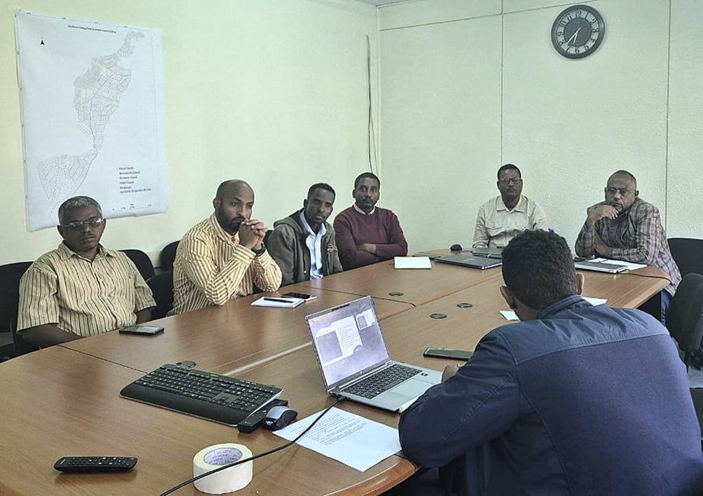
IWMI’s water accounting assessment underscored the importance of fostering strong stakeholder partnerships. Local stakeholders were closely involved in the process and validated the findings of the water accounting assessment.
Stakeholders from enterprises operating large-scale irrigated areas within the scheme and representatives from the Ministry of Irrigation and Lowlands validated the digitally reconstructed layout map during a workshop in December 2024. They confirmed that the layout accurately represented the actual ground conditions. In February 2025, the crop type maps and water accounting input data were reviewed and validated in a second workshop.
During a recent workshop on July 8, 2025, representatives from the Ministry of Irrigation and Lowlands, Ministry of Water and Energy, Ministry of Agriculture, Institute of Agricultural Research, Middle Awash Agricultural Development Enterprise and academic institutions validated the outcomes of the WA+ analysis. They confirmed the importance of the findings and echoed the concerns raised through the assessment.
“Once regarded as one of Ethiopia’s best-designed and best-managed irrigation systems, Amibara’s performance has declined in recent years due to institutional restructuring and poor management,” said Ashanafi Likassa, Small-Scale Irrigation Development Lead Executive at the Ministry of Irrigation and Lowlands. “IWMI’s evidence-based recommendations identified through remote sensing data and WA+ offer practical solutions to improve water use, restore the scheme and support our revitalization efforts.”
Stakeholders agreed that the findings accurately highlighted the urgent need for modern irrigation practices and technological upgrades. While large investments are needed to improve distribution infrastructure, introducing precision irrigation tools such as drip, sprinkler, enhanced furrows with low-cost moisture sensors and better canal lining could significantly boost water use efficiency.
Water management scenarios developed in the study demonstrated the potential savings that such interventions could generate. These would allow farmers to produce more with less water, potentially expanding irrigated areas.
Moreover, IWMI developed the Amibara Irrigation Monitoring Dashboard to provide critical insights on agricultural water demand and supply, seasonal crop water use and water use efficiency per hectare. It also highlights potential savings from adopting modern water-efficient technologies.
Broader impacts and scalability
The water accounting assessment of the Amibara Irrigation Scheme can be applied to other irrigation schemes across Ethiopia and beyond. It shows how combining remote sensing data, digital tools and field observations can improve planning and performance, even in data-scarce regions.
Stakeholders at the latest validation workshop acknowledged that IWMI’s water accounting approach is instrumental for the revitalization of the Amibara Irrigation Scheme, which is part of the new Climate Resilient Irrigation for Sustainable Production Program (CRISP). Si Gou, a senior water resources specialist at the World Bank, said: “This scalable approach has the potential to modernize and revitalize irrigation schemes far beyond Amibara.”
IWMI’s team in Ethiopia believes that smart irrigation management is not just a technical necessity; it is a strategic imperative for Ethiopia’s food security, economic growth and climate resilience. Therefore, lessons from Amibara offer a blueprint for revitalizing irrigation schemes and for building a more water and food secure future.


